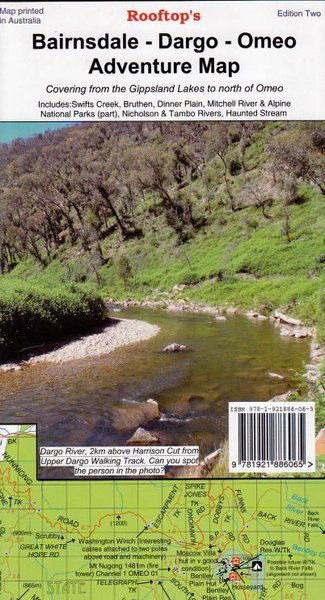

Rooftop''s Bairnsdale-Dargo-Omeo Adventure Map
SKU
8751400VIC048
$14.99
Available for delivery
Not Available For Click & Collect
Bairnsdale Dargo Omeo Rooftop: Map coverage is from Paynesville, Metung and Lakes Entrance in the south to Dinner Plain, Omeo and Mount Nugong in the north. It includes Dargo, Mitchell River National Park, Swifts Creek, Cobungra, Victoria Falls, Cassilis, Deptford, Bullumwaal, Mount Baldhead, Haunted Stream and a huge amount of forest in between. A feature is the East Gippsland rail Trail which can be followed from Bairnsdale to Colquhoun, south-east of Bruthen.
Scale is 1:100,000. The reverse of the map has a 1:50,000 scale enlargement titled 'Dargo - Swifts Creek Forest Activities Map' with contours. All parks, reserves and state forests are shown and more than 6000 km of roads and tracks have been plotted using GPS mapping technology.
- Scale is 1:100,000.
- The reverse of the map has a 1:50,000 scale enlargement titled 'Dargo - Swifts Creek Forest Activities Map' with contours.
- All parks, reserves and state forests are shown and more than 6000 km of roads and tracks have been plotted using GPS mapping technology.
Write Your Own Review

Enter your email below to receive your one time only $10 off Code.
Limited time only! Online Only! DON’T MISS OUT.
You might also be interested in
 Someone in COOGEE, Australia purchased Hoochie Cord 2mm (Sold by meter) with $0.602 minutes ago.
 Someone in COOGEE, Australia purchased OZ TRAIL FOAM EARTH MAT with $19.992 minutes ago.
 Someone in COOGEE, Australia purchased Water Proof Vinyl Ground Sheet with $19.992 minutes ago.
 Someone in Greenwich, Australia purchased 23ZERO DAKOTA SUPER LITE with $1,599.9936 minutes ago.
 Someone in Soldiers Point, Australia purchased Huss M-25 Woodland Trousers with $49.992 hours ago.
TERMS & CONDITIONS