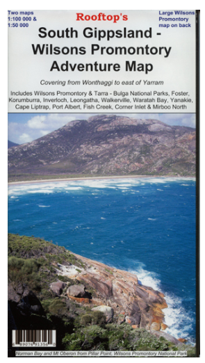

South Gippsland - Wilsons Promontory Adventure Map
SKU
8751400VIC075
$14.99
Available for delivery
Available for Click & Collect
Rooftop's South Gippsland Wilsons Promontory
Wilsons Promontory Forest Activities map on the reverse
Map coverage includes Wilsons Promontory and Tarra - Bulga National Parks, Foster, Korumburra, Inverloch, Leongatha, Walkerville, Waratah Bay, Yanakie, Cape Liptrap, Port Albert, Fish Creek, Corner Inlet, Mirboo North, Yarram, Woodside and Wonthaggi. Scale is 1:100,000.
The reverse of the map has a 1:50,000 scale enlargement titled 'Wilsons Promontory Forest Activities Map' with contours.
All parks, reserves and state forests are shown and all roads and tracks within the map area have been plotted using GPS mapping technology. All walking tracks in Wilsons Promontory National Park have been recently field checked with detailed plots showing camp sites, navigational notes and important features.
- -
- -
Write Your Own Review

Enter your email below to receive your one time only $10 off Code.
Limited time only! Online Only! DON’T MISS OUT.
You might also be interested in
 Someone in COOGEE, Australia purchased Hoochie Cord 2mm (Sold by meter) with $0.604 minutes ago.
 Someone in COOGEE, Australia purchased OZ TRAIL FOAM EARTH MAT with $19.994 minutes ago.
 Someone in COOGEE, Australia purchased Water Proof Vinyl Ground Sheet with $19.994 minutes ago.
 Someone in Greenwich, Australia purchased 23ZERO DAKOTA SUPER LITE with $1,599.9938 minutes ago.
 Someone in Soldiers Point, Australia purchased Huss M-25 Woodland Trousers with $49.992 hours ago.
TERMS & CONDITIONS