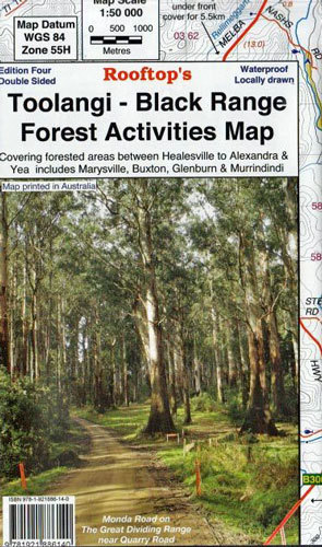

Toolangi - Black range Forest Activities Rooftop's Map
SKU
8751400VIC077
$14.99
Available for delivery
Available for Click & Collect
Toolangi Black Range Rooftop
Between the Maroondah and Melba Highways
Coverage includes Toolangi, Murrindindi, Buxton, Narbethong, Wilhelmina Falls, Stanleys Homestead, Alexandra, Taggerty, Molesworth, Glenburn, Limestone & Cheviot Tunnel.
Facility symbols include Camping Areas, Caravan Parks, Picnic Areas, Fishing Spots, Lookouts, Fuel and Fire Towers.
The 1:50,000 scale map also includes roads, 4WD, motorcycle and walking tracks, with contours, elevations, and GPS co-ordinates.
- New waterproof edition.
- Edition Edition 3.
- Publication date 2015
- Map Scale 1:50,000.
- ISBN 9.78E+12
Write Your Own Review

Enter your email below to receive your one time only $10 off Code.
Limited time only! Online Only! DON’T MISS OUT.
You might also be interested in
 Someone in Dromana, Australia purchased Blundstone 630 Kids with $99.992 hours ago.
 Someone in Dromana, Australia purchased Blundstone 600 Work Boot with $149.992 hours ago.
 Someone in Thornbury, Australia purchased Blundstone 610 Work Boot with $149.995 hours ago.
 Someone in Hackham west, Australia purchased RSW3 Haversack Back Pack with $33.245 hours ago.
TERMS & CONDITIONS